

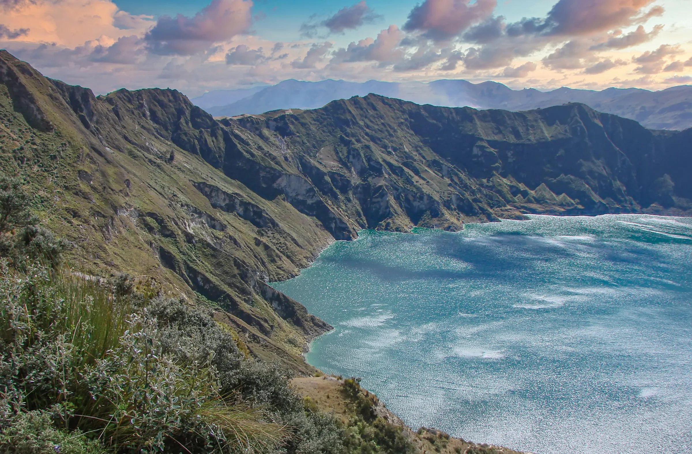
The Avenue of the Volcanoes is a broad Andean corridor rather than a single road or attraction. South of Quito, the route passes the near-symmetrical cone of Cotopaxi, the turquoise caldera at Quilotoa, fertile farming valleys, Indigenous market towns, and the high flanks of Chimborazo. Elevations change rapidly, weather can obscure the peaks without warning, and the most rewarding itineraries combine short walks, hacienda stays, village visits, and private transfers instead of focusing only on summit views.
At a glance
| Best for | Volcanoes, high-altitude scenery, hiking, horseback riding, haciendas, markets, and Andean communities |
|---|---|
| Don't miss | Cotopaxi National Park, Quilotoa, Chimborazo Reserve, Limpiopungo Lagoon, and a historic hacienda |
| Recommended stay | 4 to 7 nights |
| Best area to stay | Near Cotopaxi, Quilotoa, or Riobamba, using more than one base |
| Pairs well with | Quito, Baños, Otavalo & Imbabura, and the Galápagos Islands |
| Closest airports | Mariscal Sucre International Airport (UIO) and Mariscal Lamar Airport in Cuenca (CUE) |
| Best time to visit | June through September for generally drier conditions and clearer mornings |
| Getting around | Private transfers, guided walks, horseback riding, and specialist climbing arrangements |
| Budget | $$ to $$$$ |
Why stay along the Avenue of the Volcanoes?
Cotopaxi National Park protects páramo, wetlands, wild horses, high-altitude birdlife, and one of Ecuador's most recognizable volcanic profiles. Visitors can walk around Limpiopungo Lagoon, drive to higher trailheads when conditions permit, and stay at small haciendas with direct views of the mountain.
Quilotoa occupies a caldera west of the main highway. The lake changes from turquoise to deep green with the light, and the surrounding communities maintain farming, weaving, and market traditions. The descent from the rim is steep, and the return climb is more demanding because the viewpoint already sits at high altitude.
Farther south, Chimborazo rises to 20,548 feet. Its summit is the point on Earth's surface farthest from the planet's center because of the equatorial bulge. The surrounding reserve protects vicuñas and broad volcanic plains, with guided walks possible at several elevations below the glaciers.
The cultural landscape matters as much as the volcanoes. Markets at Saquisilí, Latacunga, Guamote, and smaller villages bring together produce, livestock, household goods, and regional clothing. Historic haciendas preserve Inca masonry, colonial courtyards, farms, and equestrian traditions that help break up the long route.
Our take: use two or three bases and keep mountain days flexible. Clear views are never guaranteed, but páramo, villages, wildlife, and hacienda experiences still make the route worthwhile when clouds cover the summits.
Is the Avenue of the Volcanoes a good fit?
- Enjoy high-altitude landscapes, geology, and mountain photography.
- Want a choice between gentle walks and demanding hikes.
- Prefer historic haciendas and rural lodges to city hotels.
- Are interested in Andean markets, farming, and Indigenous communities.
- Want an overland route between Quito, Baños, Riobamba, or Cuenca.
- Can accept variable weather and changing mountain access.
Travelers seeking nightlife or extensive resort facilities may find the region quiet. Its value comes from early mornings, rural properties, outdoor activity, and the ability to alter the day according to visibility and altitude.
Best things to do
Explore Cotopaxi National Park
Visit Limpiopungo Lagoon, cross the páramo, and walk at an elevation suited to your fitness and acclimatization. Access to higher areas can change with weather, volcanic monitoring, and park operations.
See Quilotoa Crater Lake
Walk along the rim for changing views or descend toward the water with enough time for the steep return. Nearby villages and workshops add cultural depth to the volcanic landscape.
Stay in a historic hacienda
Choose among properties with Inca foundations, working farms, equestrian programs, or direct Cotopaxi views. Fires, thick walls, and shared meals are part of the experience because highland nights are cold.
Ride across the páramo
Horseback routes cross open grassland, farm tracks, and foothills beneath the volcanoes. Experienced haciendas can match horses and routes to both first-time and advanced riders.
Look for vicuñas at Chimborazo
The Chimborazo reserve supports a restored population of wild vicuñas. Private guiding can combine wildlife observation with short walks and geological interpretation below the mountain's glaciated slopes.
Visit an Andean market
Regional markets vary by day and purpose. Some emphasize produce and livestock, while others are better known for crafts or prepared food. A guide helps interpret clothing, trade routes, and local etiquette.
Walk in the high páramo
Short routes reveal cushion plants, grasses, wetlands, volcanic soil, and birds adapted to cold equatorial conditions. The terrain may appear gentle, but elevation and wind make even modest walks more demanding.
Travel south toward Riobamba
The route between Cotopaxi and Chimborazo passes agricultural valleys, small towns, and changing volcanic views. Riobamba provides access to Chimborazo and a useful overnight before Baños or Cuenca.


Where to stay
Stay near Cotopaxi for early park access, mountain views, horseback riding, and historic haciendas. Properties around Lasso, Mulaló, and the western foothills vary from small family estates to activity-focused lodges.
Stay near Quilotoa if the crater, village walks, and quieter rural landscapes are priorities. Accommodation is simpler than around Cotopaxi, but an overnight avoids a long return journey and allows early or late light at the rim.
Stay near Riobamba or Chimborazo for vicuñas, higher-altitude walking, and continuation toward Baños or Cuenca. Riobamba has practical city hotels, while rural properties outside town provide a stronger connection to the landscape.
We recommend at least two bases. A single hotel creates long daily transfers and leaves too little flexibility when weather changes around the peaks.
Our favorite hotels
Hacienda San Agustín de Callo
This 15-room hacienda incorporates surviving Inca stonework into colonial and republican buildings below Cotopaxi. The property has fireplaces, murals, home-style meals, and the archaeological setting.
Hacienda La Alegría
This working family hacienda is known for its horses and multi-day riding routes through the Cotopaxi countryside. It suits active travelers who want equestrian experience to define the stay rather than simply add a one-hour ride.
Hacienda El Porvenir
El Porvenir is a larger working hacienda close to Cotopaxi National Park, with horseback riding, mountain biking, walking, and a broad range of room types. It works especially well for families and small groups seeking several activity levels.
Chimborazo Lodge
This small mountain lodge sits high on the slopes of Chimborazo with immediate access to páramo, vicuñas, and walking routes. The remote setting and simple comfort suit travelers who prioritize the mountain over full-service hotel facilities.
Best time to visit
June through September is generally the driest period, with cold nights, strong sun, and clearer mornings. December and January can also bring good visibility, but conditions remain highly local because each volcano creates its own weather.
Rain is more frequent from February through May and October through November. Green landscapes and fewer visitors can be advantages, but muddy trails, cloud, and road conditions require more flexibility.
Pair it with
- Quito for museums, architecture, and acclimatization before higher terrain.
- Baños for waterfalls, thermal bathing, and the descent toward the Amazon.
- Otavalo & Imbabura for textiles, crater lakes, and northern haciendas.
- The Galápagos Islands for a mainland mountain contrast to the archipelago.
Getting there
The northern section begins south of Quito and follows the Pan-American corridor toward Latacunga and Riobamba. Quilotoa requires a substantial detour west, while Chimborazo sits beyond Riobamba. Private transfers allow stops and walking distances to be adapted around weather and altitude.
Approximate travel times:
- Quito to Cotopaxi National Park: 1.5 to 2.5 hours
- Cotopaxi area to Quilotoa: 2 to 3 hours
- Cotopaxi area to Riobamba: 2.5 to 3.5 hours
- Riobamba to Chimborazo Reserve: 1 to 1.5 hours
- Riobamba to Baños: 1.5 to 2 hours
- Riobamba to Cuenca: 4.5 to 5.5 hours
Road times change with market traffic, weather, and mountain access. We avoid tight flight connections after a long overland day and place the highest walks after travelers have spent time acclimatizing.


Frequently asked questions
How many nights should I spend along the Avenue of the Volcanoes?
Four nights allow two bases around Cotopaxi and Chimborazo or Quilotoa. Six or seven nights provide time for all three areas, village visits, horseback riding, and weather flexibility.
Can Cotopaxi be visited as a day trip from Quito?
Yes, but an overnight provides earlier park access, a better chance of clear views, and time for riding or a second walk. It also prevents the day from being dominated by city traffic.
Do I need to climb a volcano?
No. Most visitors experience the region through short walks, lagoons, viewpoints, haciendas, and wildlife. Technical summit attempts require specialist operators, strong fitness, acclimatization, equipment, and current mountain-condition checks.
How difficult is the altitude?
Many attractions sit well above Quito, and the road reaches very high elevations. Begin with lower or shorter activities, drink water, and avoid combining a long transfer with the most demanding walk. Seek medical advice before travel if you have relevant health concerns.
Will I definitely see Cotopaxi and Chimborazo?
No. Cloud can cover the summits in any month, sometimes within minutes. Early starts improve the odds, but a good itinerary also includes wildlife, culture, and walks that remain worthwhile without a clear peak.
Is Quilotoa a separate destination?
It can be. The crater sits west of the main Avenue route and requires a detour. An overnight is worthwhile for hikers, photographers, and travelers who want village experiences rather than a brief rim stop.
Is the region suitable for families?
Yes, with the right pace. Lagoons, horses, farms, markets, and shorter walks work well for families. High elevations, cold wind, and long drives need to be considered when selecting activities.
What should I pack?
Bring warm layers, a waterproof and wind-resistant shell, sun protection, gloves, a hat, and supportive shoes. Temperatures can change quickly, and strong equatorial sun is possible even in cold air.


